Looks like it’s headed our way now.
There’s been a definite westward shift over the last day or so.
I’ve got family in the Beaumont area that has had to deal with major damage from Rita, Ike, and Harvey, and it’s not looking so good for them right now either. At least they won’t be on the “dirty” side of the storm (at least right now), but it’s still gonna suck for them.
It looks most like Ike at this point. Buckle up folks, this will not be fun.
Be safe!
I remember hurricane Carla.
This one bears watching. The current official forecast is on the eastern periphery of guidance and guidance has been shifting west the last few runs and very noticeably so in the last package. Watching the strength of the inverted trough over Texas now will be key at assessing subsequent track guidance.
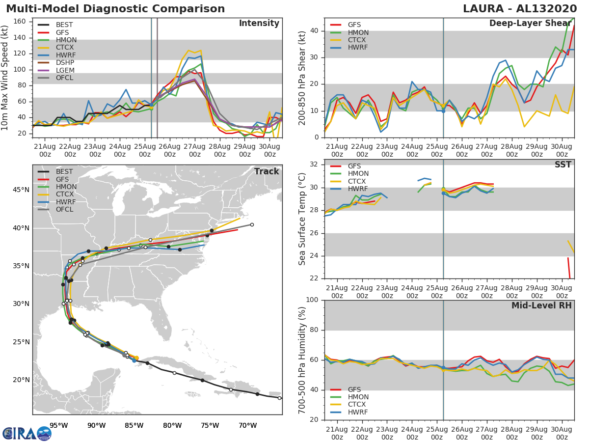
Even though the storm is forecast to reach the low end of Major status prior to landfall, the forecast intensity is at the lower end of guidance. Most models are now suggesting a period of rapid intensification sometime in the next two days over the super warm Gulf Loop and in a low shear environment. Once you see the CDO looking less ragged and “pulsey”, that’s when the RI will start. The one saving grace is shear is forecast to increase as the storm approaches the coast so that should promote some weakening prior to landfall. That’s still a couple days out so confidence is somewhat low there.
Pay close attention to local authorities and heed their warnings and orders. Stay safe, all!!!
3 Likes
ugh
Thanks, das (David)
Yes, thanks das. I always appreciate your input.
Yeah, love reading your expertise. I’m always fascinated by this modeling.
Over the last couple of days, it seemed like the models had come together at the LA/TX border with little mention of a westward shift. I’m surprised at even a minor shift as these folks have gotten pretty good at this over the last decade.
The models did eventually have it heading for the border, then shifted it east of Lake Charles on Sunday night, and are now pulling it back west.
https://www.nhc.noaa.gov/archive/2020/LAURA_graphics.php?product=5day_cone_with_line_and_wind
The models are good (and getting even better each year) but forecaster input, interpreting that model output (and so many other data inputs) makes all the difference in the actual forecast. Models are getting better but forecaster knowledge is getting better at the same pace.
And, yet, sometimes, it all falls apart. Marco was a perfect example. By all accounts, it was a busted forecast, even with forecasters trying to correct stubborn model output that was clearly getting it wrong on both intensity and location. You can see it here clearly as the official forecast corrected and recorrected to the right over time:
https://www.nhc.noaa.gov/archive/2020/MARCO_graphics.php?product=5day_cone_with_line
DAS, thanks. What is CDO and RI?
The models did eventually have it heading for the border, then shifted it east of Lake Charles on Sunday night, and are now pulling it back west.
[/quote]
Precisely. And, those shifts are all based on weaknesses in the subtropical ridge dominating the Southeast. And, those weaknesses are transient on a <12H scale and based on where thunderstorms set up each day, driven by hyper-local convective processes. It’s mostly cloudy in Northern Louisiana instead of partly cloudy one afternoon so thunderstorms set up 50 miles to the east and that affects the path of a developing hurricane 2,000 miles to the south, affecting its projected landfall two days later by 200 miles. That’s the kind of nuance we’re talking about.
Central Dense Overcast (that area of roiling cirrus clouds right around the center of the storm. And, Rapid Intensification, characterized by a 24 hour increase in wind speed of >35mph (and used to be a drop in central pressure of 42mb).
Thanks.
Bleh, latest westward trend on the models:
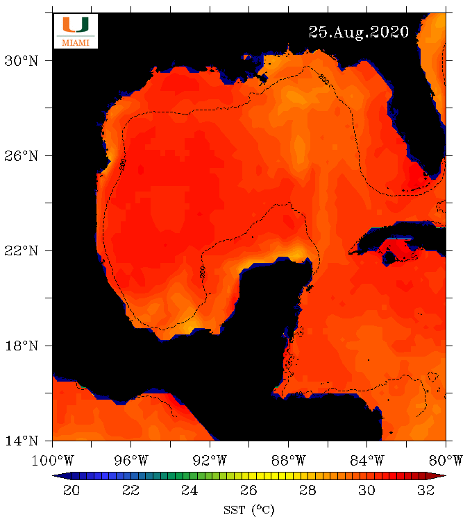
…has the storm missing most of Marco’s 28C wake left in the warm Gulf (seen in the right center of this image as the cooler yellow temps) and instead, spending most of the time over 30-31C areas.
A very good forecaster friend that I trust just suggested 140mph directed at Galveston Bay. Like I said earlier, pay close attention to local authorities and heed their warnings and orders.
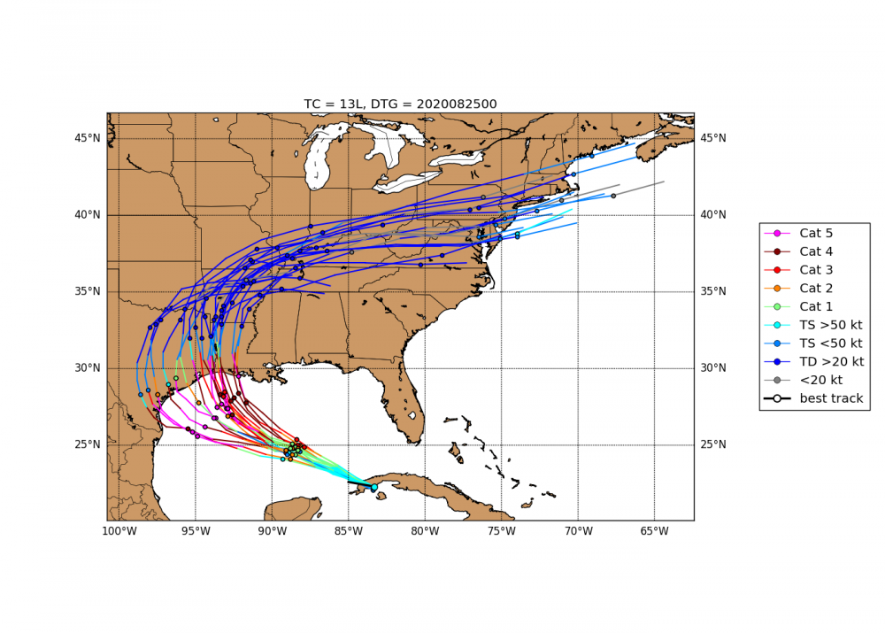
Curious, are these models at a public site, and why is the initial data point east of Cuba instead of the current location?
@JBM, that was the last ensemble of model runs 12 hours ago. The next will come out shortly.
The data is here: Global Ensemble Forecast System (GEFS) | National Centers for Environmental Information (NCEI) formerly known as National Climatic Data Center (NCDC)
You can also get easier to read versions at enthusiast sites like Tropical Tidbits.
Edited to add: here’s a good ensemble page from the Cooperative Institute for Research in the Atmosphere (CIRA). A great gov/academic consortium. Updates are frequent:
1 Like
Thanks, das.
1 Like
I’m not sure I’ve seen a spaghetti model that had as little general consensus two days from landfall as this one does. It looks like ~40% of them have it hitting west of Houston.
Also, if I’m reading the colors correctly, over half of those are forecasting category 4 or 5 at landfall. This could be really bad no matter where it hits, but anywhere between Corpus and Beaumont will be especially devastating.
Yes, you are reading those colors correctly. Take a look at the plot form CIRA I posted above. 12 hours and post-interaction with Cuba has created much, much more consensus.
1 Like